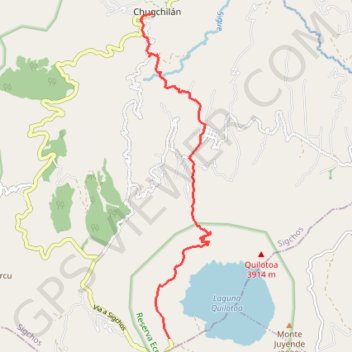
Chugchilan to Quilotoa
- Distance: 11.4 Km
- Elevation gain: 1,074 m
- Maximum elevation: 3,877 m
- Elevation loss: 395 m
- Minimum elevation: 2,950 m
- Moving time: 4 h 46 m
- Moving speed: 2.4 Km/h
- Maximum speed: 4.5 Km/h
- Total time: 5 h 59 m
- Global speed: 1.9 Km/h
- Date: 24/02/17
Interactive map
GPS track profile
About this GPS track
Name: Chugchilan to Quilotoa GPS track, route, trail
Start: Itupungo Bajo, Chugchillan, Sigchos, Cotopaxi, 050504, Équateur (-0.79918 -78.91966)
Coordinates: -0.86674 -78.92221 -0.79918 -78.90752
Other GPS tracks
Click on a GPS track to view route, its statistics and profile.
Ecu_24_Quilotoa
Équateur > Cotopaxi > Pujilí > Zumbahua > Tigua Rumichaca
Distance: 50.9 Km • Elevation gain: 2,368 m • Maximum elevation: 3,886 m