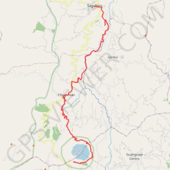
Sigchos - Macapungu Quilotoa
- Distance: 35.2 Km
- Elevation gain: 2,392 m
- Maximum elevation: 3,868 m
- Elevation loss: 1,410 m
- Minimum elevation: 2,532 m
- Moving time: 8 h 33 m
- Moving speed: 4.1 Km/h
- Maximum speed: 12.5 Km/h
- Total time: 1 d 51 m
- Global speed: 1.4 Km/h
- Date: 30/11/17
Interactive map
GPS track profile
About this GPS track
Name: Sigchos - Macapungu Quilotoa GPS track, route, trail
Start: Restaurante Lucia, Ilinizas, Culacusi, Sigchos, Cotopaxi, 050750, Équateur (-0.70544 -78.88891)
Coordinates: -0.87145 -78.92422 -0.70531 -78.87368
Other GPS tracks
Click on a GPS track to view route, its statistics and profile.
Ecu_24_Quilotoa
Équateur > Cotopaxi > Pujilí > Zumbahua > Tigua Rumichaca
Distance: 50.9 Km • Elevation gain: 2,368 m • Maximum elevation: 3,886 m
Chugchilan to Quilotoa
Équateur > Cotopaxi > Sigchos > Chugchillan > Itupungo Bajo
Distance: 11.4 Km • Elevation gain: 1,074 m • Maximum elevation: 3,877 m