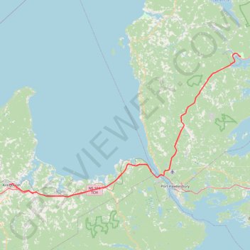
Antigonish - Whycocomagh
Gulf of Saint Lawrence. Cape Breton Island. #Bike #Antigonish #Whycocomagh #SaintLawrence #CapeBreton
- Distance: 104.0 Km
- Elevation gain: 891 m
- Maximum elevation: 135 m
- Elevation loss: 871 m
- Minimum elevation: -2 m
Interactive map
GPS track profile
About this GPS track
Name: Antigonish - Whycocomagh GPS track, route, trail
Coordinates: 45.58864 -61.99721 45.97546 -61.10311
Other GPS tracks
Click on a GPS track to view route, its statistics and profile.
Salt Mountain Loop
Canada > Nova Scotia > Municipality of the County of Inverness > Whycocomagh
Distance: 4.1 Km • Elevation gain: 272 m • Maximum elevation: 231 m
Pictou - Antigonish
Canada > Nova Scotia > Town of Pictou > Pictou
Gulf of Saint Lawrence. #Bike #Pictou #Antigonish #SaintLawrence #Atlantic
Distance: 101.8 Km • Elevation gain: 808 m • Maximum elevation: 147 m
Pictou - Antigonish
Canada > Nova Scotia > Town of Pictou > Pictou
#Bike #Pictou #Antigonish
Distance: 74.3 Km • Elevation gain: 744 m • Maximum elevation: 154 m