Pictou - Antigonish
#Bike #Pictou #Antigonish
- Distance: 74.3 Km
- Elevation gain: 744 m
- Maximum elevation: 154 m
- Elevation loss: 757 m
- Minimum elevation: 1 m
Interactive map
GPS track profile
About this GPS track
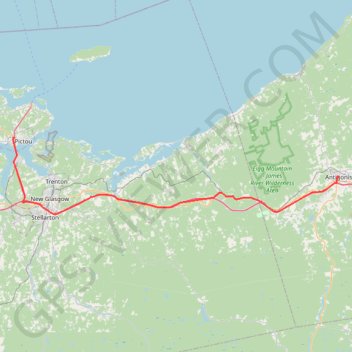
Name: Pictou - Antigonish GPS track, route, trail
Coordinates: 45.56148 -62.73120 45.68325 -61.99465
Other GPS tracks
Click on a GPS track to view route, its statistics and profile.
Trenton Park - Airport Route
Canada > Nova Scotia > Town of Trenton > Town of Trenton
Purple Route
Distance: 3.5 Km • Elevation gain: 37 m • Maximum elevation: 100 m
Antigonish - Whycocomagh
Canada > Nova Scotia > Town of Antigonish > Antigonish
Gulf of Saint Lawrence. Cape Breton Island. #Bike #Antigonish #Whycocomagh #SaintLawrence #CapeBreton
Distance: 104.0 Km • Elevation gain: 891 m • Maximum elevation: 135 m
Pictou - Antigonish
Canada > Nova Scotia > Town of Pictou > Pictou
Gulf of Saint Lawrence. #Bike #Pictou #Antigonish #SaintLawrence #Atlantic
Distance: 101.8 Km • Elevation gain: 808 m • Maximum elevation: 147 m
Pictou - Brookfield
Canada > Nova Scotia > Town of Pictou > Pictou
#Bike #Pictou #Brookfield
Distance: 71.5 Km • Elevation gain: 535 m • Maximum elevation: 208 m