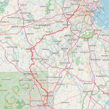
Cambridge - Providence Express
Alewife -> Providence
- Distance: 101.8 Km
- Elevation gain: 961 m
- Maximum elevation: 107 m
- Elevation loss: 966 m
- Minimum elevation: 0 m
- Moving time: 5 h 23 m
- Moving speed: 18.9 Km/h
- Maximum speed: 46.6 Km/h
- Total time: 5 h 48 m
- Global speed: 17.5 Km/h
- Date: 13/01/24
Interactive map
GPS track profile
About this GPS track
Name: Cambridge - Providence Express GPS track, route, trail
Coordinates: 41.82576 -71.51892 42.39526 -71.14072
Other GPS tracks
Click on a GPS track to view route, its statistics and profile.
My Warner Trail hike in F. Gilbert Hills State Forest
United States > Massachusetts > Norfolk County > Foxborough > South Foxboro
Distance: 13.8 Km • Elevation gain: 219 m • Maximum elevation: 134 m
Wellesley wandering
United States > Massachusetts > Middlesex County > Newton
Some Wellesley trails
Distance: 66.6 Km • Elevation gain: 611 m • Maximum elevation: 106 m
Hudson Snack Loop
United States > Massachusetts > Middlesex County > Medford > West Medford
Assabat River Trail Hudson -> Maynard
Distance: 103.7 Km • Elevation gain: 736 m • Maximum elevation: 140 m
BruceFreemen and MCRT in Sudbury
United States > Massachusetts > Middlesex County > Newton
Sudbury sections of Bruce Freeman and new MCRT section from Union St
Distance: 85.0 Km • Elevation gain: 695 m • Maximum elevation: 90 m
Medford trails
United States > Massachusetts > Middlesex County > Newton
Distance: 74.0 Km • Elevation gain: 684 m • Maximum elevation: 94 m
Cutler Park Reservation Loop
United States > Massachusetts > Middlesex County > Newton
Loop hike from Newton Highlands via Winchester Street, Nahanton Park, Charles River, Kendrick Street, Healthy Heart Trail, Kendrick Pond, Blue Heron Trail, Powells Island, Fourth Avenue, Upper Charles River Reservation and Needham Street. #Hike #Loop #Nature #Forest #River #City
Distance: 16.6 Km • Elevation gain: 108 m • Maximum elevation: 49 m
Borderland Park Loop
United States > Massachusetts > Norfolk County > Sharon
Loop hike in the Borderland State Park via Northwest Trail, Split Rock Trail, Granite Hills Trail, Granite Hills Lower Loop, Tisdale Road, Upper Leach Pond, Puds Pond, Pond Walk, Leach Pond, Pond Edge Trail, West Side Trail and The French Trail. #Hike #Loop #Park #Nature #Lake #Forest
Distance: 9.4 Km • Elevation gain: 81 m • Maximum elevation: 97 m
ASP QUARRY
United States > Massachusetts > Middlesex County > Ashland
Quarry Route in Ashland
Distance: 2.9 Km • Elevation gain: 41 m • Maximum elevation: 105 m