Red Rock Canyon Loop
Loop hike through Red Rock Canyon Open Space via Contemplative Trail, Roundup Trail, Mesa Trail, Greenlee Trail, Quarry Pass Trail, Lyons Sandstone Quarry and Red Rock Canyon Trail. #Hike #Loop #Rock #Nature #Canyon #Forest
- Distance: 7.2 Km
- Elevation gain: 203 m
- Maximum elevation: 2,009 m
- Elevation loss: 205 m
- Minimum elevation: 1,883 m
- Moving time: 2 h 1 m
- Moving speed: 3.6 Km/h
- Maximum speed: 5.8 Km/h
- Total time: 2 h 26 m
- Global speed: 3.0 Km/h
- Date: 20/06/14
Interactive map
GPS track profile
About this GPS track
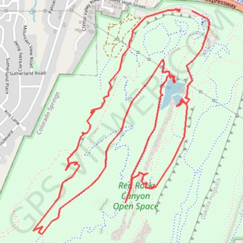
Name: Red Rock Canyon Loop GPS track, route, trail
Coordinates: 38.84065 -104.89146 38.85364 -104.87842
Other GPS tracks
Click on a GPS track to view route, its statistics and profile.
Red Rock Canyon
United States > Colorado > El Paso County > Colorado Springs
Chamberlain Trail
Distance: 1.8 Km • Elevation gain: 82 m • Maximum elevation: 1,967 m