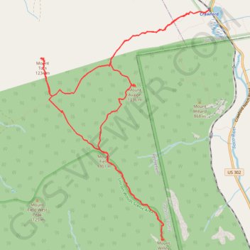
Mount Field, Mount Willey, Mount Avalon and Mount Tom Loop
Loop hike from Sako Lake via Avalon Trail, Mount Avalon, Mount Field, Willey Range Trail, Mount Willey, Mount Tom Spur, Mount Tom and A-Z Trail in the White Mountain National Forest. #Hike #Loop #Mountain #Nature #Forest #Lake
- Distance: 15.2 Km
- Elevation gain: 1,021 m
- Maximum elevation: 1,299 m
- Elevation loss: 1,021 m
- Minimum elevation: 575 m
- Moving time: 4 h 41 m
- Moving speed: 3.2 Km/h
- Maximum speed: 5.1 Km/h
- Total time: 5 h 33 m
- Global speed: 2.7 Km/h
- Date: 23/08/23
Interactive map
GPS track profile
About this GPS track
Name: Mount Field, Mount Willey, Mount Avalon and Mount Tom Loop GPS track, route, trail
Start: Crawford, Avalon Trail, Carroll, Coös County, New Hampshire, United States (44.21778 -71.41122)
End: Crawford, Avalon Trail, Carroll, Coös County, New Hampshire, United States (44.21771 -71.41122)
Coordinates: 44.18331 -71.44647 44.21778 -71.41122
Other GPS tracks
Click on a GPS track to view route, its statistics and profile.