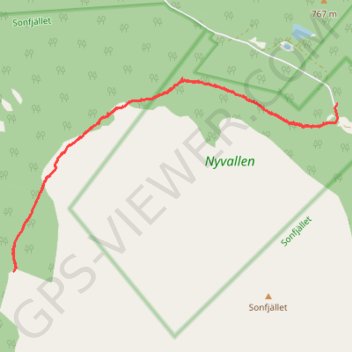
17-OCT-21 14:49:35
- Distance: 9.4 Km
- Elevation gain: 290 m
- Maximum elevation: 909 m
- Elevation loss: 266 m
- Minimum elevation: 765 m
- Moving time: 3 h 2 m
- Moving speed: 3.1 Km/h
- Maximum speed: 4.7 Km/h
- Total time: 5 h 10 m
- Global speed: 1.8 Km/h
- Date: 17/10/21
Interactive map
GPS track profile
About this GPS track
Name: 17-OCT-21 14:49:35 GPS track, route, trail
Start: Nyvallen, Härjedalens kommun, Comté de Jämtland, Suède (62.31764 13.56463)
End: Nyvallen, Härjedalens kommun, Comté de Jämtland, Suède (62.31594 13.56425)
Coordinates: 62.30243 13.50142 62.31993 13.56489
Other GPS tracks
Click on a GPS track to view route, its statistics and profile.
Stage 1: Arctic Ocean to Väylä — European Divide Trail
Distance: 2,785.0 Km • Elevation gain: 23,823 m • Maximum elevation: 722 m
16-OCT-21 15:16:03
Distance: 11.8 Km • Elevation gain: 297 m • Maximum elevation: 893 m