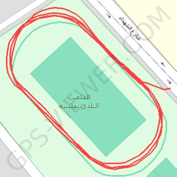
Course à pied le soir
- Distance: 1.5 Km
- Elevation gain: 7 m
- Maximum elevation: 6 m
- Elevation loss: 6 m
- Minimum elevation: 2 m
- Moving time: 10 m 6 s
- Moving speed: 9.0 Km/h
- Maximum speed: 11.4 Km/h
- Total time: 10 m 6 s
- Global speed: 9.0 Km/h
- Date: 20/09/22
Interactive map
GPS track profile
About this GPS track
Name: Course à pied le soir GPS track, route, trail
Start: شارع الشهداء, Kelibia, قليبية الغربية, معتمدية قليبية, Nabeul, 8090, Tunisia (36.84277 11.09874)
Coordinates: 36.84207 11.09697 36.84347 11.09874
Other GPS tracks
Click on a GPS track to view route, its statistics and profile.
Running 2/23/23 5:43 pm
Tunisia > Nabeul > قليبية الغربية > Kelibia
Distance: 0.5 Km • Elevation gain: 3 m • Maximum elevation: 6 m