Segment 1-500
- Distance: 29.1 Km
- Elevation gain: 257 m
- Maximum elevation: 374 m
- Elevation loss: 267 m
- Minimum elevation: 284 m
Interactive map
GPS track profile
About this GPS track
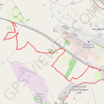
Name: Segment 1-500 GPS track, route, trail
End: Bardallur, Valdejalón, Saragosse, Aragon, Espagne (41.68500 -1.15894)
Coordinates: 41.61995 -1.17931 41.69036 -1.02483
Other GPS tracks
Click on a GPS track to view route, its statistics and profile.
Southern section — European Divide Trail
France > Auvergne-Rhône-Alpes > Drôme > Valence
Distance: 2,423.8 Km • Elevation gain: 42,375 m • Maximum elevation: 2,005 m
1 LUCENA - MONTPELLIER
Distance: 2,964.4 Km • Elevation gain: 29,500 m • Maximum elevation: 1,048 m
1 LUCENA - MONTPELLIER
Espagne > Andalousie > Lucena
Distance: 2,964.4 Km • Elevation gain: 29,500 m • Maximum elevation: 1,048 m
Stage 26: Valence to Saint-Jean-de-Fos — European Divide Trail
France > Auvergne-Rhône-Alpes > Drôme > Valence
Distance: 2,423.8 Km • Elevation gain: 42,375 m • Maximum elevation: 2,005 m
Stage 26: Valence to Saint-Jean-de-Fos — European Divide Trail
France > Auvergne-Rhône-Alpes > Drôme > Valence
Distance: 1,629.8 Km • Elevation gain: 30,841 m • Maximum elevation: 2,005 m
De Villeneuve-sur-Lot à Guimarães
France > Nouvelle-Aquitaine > Lot-et-Garonne > Villeneuve-sur-Lot
Distance: 2,024.3 Km • Elevation gain: 22,121 m • Maximum elevation: 1,339 m