Ecu_25_Mirador_de_la_Virgen
- Distance: 3.9 Km
- Elevation gain: 417 m
- Maximum elevation: 2,192 m
- Elevation loss: 468 m
- Minimum elevation: 1,808 m
Interactive map
GPS track profile
About this GPS track
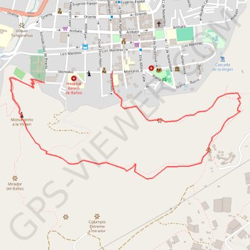
Name: Ecu_25_Mirador_de_la_Virgen GPS track, route, trail
Coordinates: -1.40595 -78.42946 -1.39988 -78.41640
Other GPS tracks
Click on a GPS track to view route, its statistics and profile.
Ecu_26_Casa_del_Arbol
Équateur > Tungurahua > Baños > Baños de Agua Santa > Baños
Distance: 7.9 Km • Elevation gain: 761 m • Maximum elevation: 2,594 m