Milenkov Kamen (Karadzica)
- Distance: 10.4 Km
- Elevation gain: 1,024 m
- Maximum elevation: 2,200 m
- Elevation loss: 1,282 m
- Minimum elevation: 958 m
- Moving time: 5 h 42 m
- Moving speed: 1.8 Km/h
- Maximum speed: 23.7 Km/h
- Total time: 6 h 50 m
- Global speed: 1.5 Km/h
- Date: 02/01/21
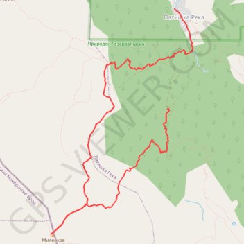
Interactive map
GPS track profile
About this GPS track
Name: Milenkov Kamen (Karadzica) GPS track, route, trail
Start: Patishka Reka, Municipality of Sopishte, Skopje Region, North Macedonia (41.78641 21.31441)
Coordinates: 41.76872 21.29247 41.80052 21.31931
Other GPS tracks
Click on a GPS track to view route, its statistics and profile.
Patiška Reka-Milenkov kamen-Mirska voda-Patiska reka
North Macedonia > Skopje Region > Patishka Reka
Distance: 14.6 Km • Elevation gain: 1,342 m • Maximum elevation: 2,202 m