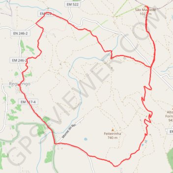
Reguendo
Interactive map
GPS track profile
About this GPS track
Name: Reguendo GPS track, route, trail
Start: EM 246-2, Reguengo e São Julião, Portalegre, 7300-404, Portugal (39.29805 -7.39252)
End: EM 246-2, Reguengo e São Julião, Portalegre, 7300-404, Portugal (39.29803 -7.39256)
Coordinates: 39.28221 -7.39260 39.31336 -7.35811
Other GPS tracks
Click on a GPS track to view route, its statistics and profile.
Southern section — European Divide Trail
France > Auvergne-Rhône-Alpes > Drôme > Valence
Distance: 2,423.8 Km • Elevation gain: 42,375 m • Maximum elevation: 2,005 m
EuroVelo 1 (Spain)
Espagne > Andalousie > Côte occidentale > Ayamonte
Distance: 1,355.6 Km • Elevation gain: 14,587 m • Maximum elevation: 1,320 m
Eurovelo 01 Spain + Portugal
France > Nouvelle-Aquitaine > Pyrénées-Atlantiques > Hendaye
Distance: 3,107.2 Km • Elevation gain: 30,592 m • Maximum elevation: 1,503 m
Stage 26: Valence to Saint-Jean-de-Fos — European Divide Trail
France > Auvergne-Rhône-Alpes > Drôme > Valence
Distance: 2,423.8 Km • Elevation gain: 42,375 m • Maximum elevation: 2,005 m
LLOR2022_Final_10K_CP
Portugal > Faro > Vila Real de Santo António > Monte Gordo
Distance: 946.0 Km • Elevation gain: 20,227 m • Maximum elevation: 1,130 m