Belfast to Dungannon
Bicycle ride from Belfast Big Fish to Dungannon.
- Distance: 83.3 Km
- Elevation gain: 549 m
- Maximum elevation: 75 m
- Elevation loss: 494 m
- Minimum elevation: 0 m
- Moving time: 4 h 7 m
- Moving speed: 20.2 Km/h
- Maximum speed: 52.8 Km/h
- Total time: 5 h 52 m
- Global speed: 14.2 Km/h
- Date: 04/04/24
Interactive map
GPS track profile
About this GPS track
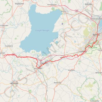
Name: Belfast to Dungannon GPS track, route, trail
Coordinates: 54.42456 -6.74527 54.60128 -5.91393
Other GPS tracks
Click on a GPS track to view route, its statistics and profile.
RT5-1 Rosslare - Kinsale
Distance: 2,860.3 Km • Elevation gain: 27,381 m • Maximum elevation: 420 m
CTS-N.Irelandv1.1-Belfast-Titanic>Enniscrone-via antrim coast-209miles
United Kingdom > Northern Ireland > County Down > Belfast
Distance: 335.8 Km • Elevation gain: 3,985 m • Maximum elevation: 271 m
TT22 J4 J2/06 : Dublin à Belfast
Irlande > County Dublin > Dublin
Distance: 250.3 Km • Elevation gain: 2,609 m • Maximum elevation: 390 m
RT5-1 Rosslare - Kinsale
Distance: 3,867.1 Km • Elevation gain: 36,115 m • Maximum elevation: 524 m
Lagan & Lough
United Kingdom > Northern Ireland > County Antrim > Tullynacross
Distance: 29.4 Km • Elevation gain: 153 m • Maximum elevation: 35 m
Newry Canal Towpath
United Kingdom > Northern Ireland > County Armagh > Portadown
Distance: 32.3 Km • Elevation gain: 95 m • Maximum elevation: 29 m