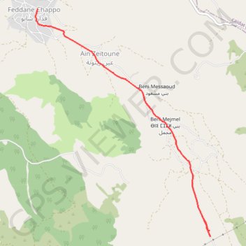
Saved_2020-01-21-18-42
- Distance: 5.1 Km
- Elevation gain: 23 m
- Maximum elevation: 477 m
- Elevation loss: 227 m
- Minimum elevation: 264 m
- Moving time: 16 m 26 s
- Moving speed: 18.7 Km/h
- Maximum speed: 48.8 Km/h
- Total time: 23 m 39 s
- Global speed: 13.0 Km/h
- Date: 22/01/20
Interactive map
GPS track profile
About this GPS track
Name: Saved_2020-01-21-18-42 GPS track, route, trail
Coordinates: 35.75704 -5.71633 35.78812 -5.68687
Other GPS tracks
Click on a GPS track to view route, its statistics and profile.
Maroc en boucle depuis Tanger
Maroc > pachalik de Tanger > Tanger
Distance: 3,028.7 Km • Elevation gain: 27,253 m • Maximum elevation: 2,301 m