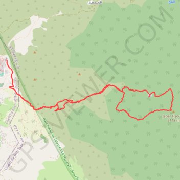
T2020-03-01-18-39
- Distance: 12.3 Km
- Elevation gain: 1,488 m
- Maximum elevation: 2,096 m
- Elevation loss: 1,420 m
- Minimum elevation: 638 m
- Moving time: 5 h 14 m
- Moving speed: 2.3 Km/h
- Maximum speed: 13.2 Km/h
- Total time: 9 h 24 m
- Global speed: 1.3 Km/h
- Date: 01/03/20
Interactive map
GPS track profile
About this GPS track
Name: T2020-03-01-18-39 GPS track, route, trail
Coordinates: 35.15920 -5.25635 35.17099 -5.21643
Other GPS tracks
Click on a GPS track to view route, its statistics and profile.
Maroc en boucle depuis Tanger
Maroc > pachalik de Tanger > Tanger
Distance: 3,028.7 Km • Elevation gain: 27,253 m • Maximum elevation: 2,301 m
Ceuta -> Ouarzazat -> Ceuta espagne
Distance: 804.6 Km • Elevation gain: 9,737 m • Maximum elevation: 2,191 m
Saved_2020-03-01-19-04
Distance: 12.2 Km • Elevation gain: 1,488 m • Maximum elevation: 2,096 m