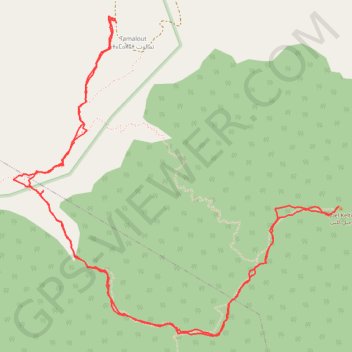
T2020-03-15-16-19
- Distance: 11.2 Km
- Elevation gain: 1,020 m
- Maximum elevation: 1,922 m
- Elevation loss: 1,027 m
- Minimum elevation: 915 m
- Moving time: 4 h 32 m
- Moving speed: 2.5 Km/h
- Maximum speed: 7.5 Km/h
- Total time: 6 h 13 m
- Global speed: 1.8 Km/h
- Date: 15/03/20
Interactive map
GPS track profile
About this GPS track
Name: T2020-03-15-16-19 GPS track, route, trail
Coordinates: 35.35043 -5.29917 35.37050 -5.27414
Other GPS tracks
Click on a GPS track to view route, its statistics and profile.
Maroc en boucle depuis Tanger
Maroc > pachalik de Tanger > Tanger
Distance: 3,028.7 Km • Elevation gain: 27,253 m • Maximum elevation: 2,301 m
Ceuta -> Ouarzazat -> Ceuta espagne
Distance: 804.6 Km • Elevation gain: 9,737 m • Maximum elevation: 2,191 m
T2020-03-15-10-02
Maroc > cercle de Tétouan > Bni Said > Bni Said
Distance: 23.6 Km • Elevation gain: 1,198 m • Maximum elevation: 987 m