Import a GPX file

South Canterbury

#Bike #Loop

  • Distance: 115.9 Km
  • Elevation gain: 312 m
  • Maximum elevation: 61 m
  • Elevation loss: 307 m
  • Minimum elevation: 3 m

Interactive map

GPS track profile

About this GPS track
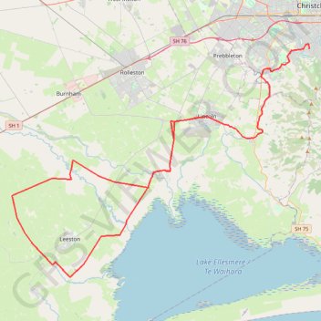
Other GPS tracks

Click on a GPS track to view route, its statistics and profile.

Tour Te Waipounamu

New Zealand > Tasman > Tasman District > Port Pūponga

Bikepacking race through the South Island of New Zealand. #Bike #Race #Island #Sea #Pacific #Ocean #Nature #Mountain #Forest #Countryside

Distance: 1,321.0 Km • Elevation gain: 23,362 m • Maximum elevation: 1,946 m